


Katanga geology and mining sector
Geology of Katanga: Overview
Introduction
The geology of southeastern Democratic Republic of Congo (DRC) and Zambia is characterised by several Precambrian orogenic belts among which the Kibaride, Irumide and Lufilian belts. The copper, cobalt and uranium deposits in Katanga are more specifically constrained in the Lufilian belt, running as an arcuate structure across the DRC-Zambian border.
The outcropping rocks are composed from north to south of Neoproterozoic detrital and carbonate formations, magmatic inliers (Domes region, northern Zambia) and metamorphic complexes.
These rocks were folded and thrusted during the Lufilian orogeny (ca. 550 Ma) resulting from the amalgamation of the Congo and Kalahari cratons.
The lithology in the Lufilian belt, in Katanga and northern Zambia, reveals the presence of a Palaeoproterozoic basement underneath a Neoproterozoic cover, the Kundelungu Supergroup.
Lithology
The Palaeoproterozoic basement is divided into the “lower basement” and the “upper basement”. The basement in the Lufilian belt, overlaid by the Katangan Supergroup, consists of the “lower basement”, which are rocks of Eburnean age (granites, gneisses and schists). In Zambia, directly covering the basement and prior to the Katanga deposition, the “upper basement”, the Muva Supergroup consists mainly of schists, quartzites, quartz-muscovite schists. It is encountered in the Lufilian Belt but limited to the Kafue Anticline, in the centre of the Luswishi Dome and locally in the Chingola area. This group was deformed and metamorphosed within the Irumide Belt during the Kibaran cycle (1350- 1100 Ma).
The intrusive rocks (mostly felsic magmatic) are considered as pre-tectonic (e.g. Nchanga Granite, Lusaka Granite, affecting the basement) as well as syntectonic (Porada and Berhorst, 2000) to the Katanga Supergroup (e.g. Ngoma Gneiss).
In the Lufilian Belt, the boundary between the basement and the katangan succession is marked by the Nchanga Granite (ca. 877 +/- 11 Ma) unconformably overlied by conglomerates, arkoses and quartzites of the Lower Roan Group.
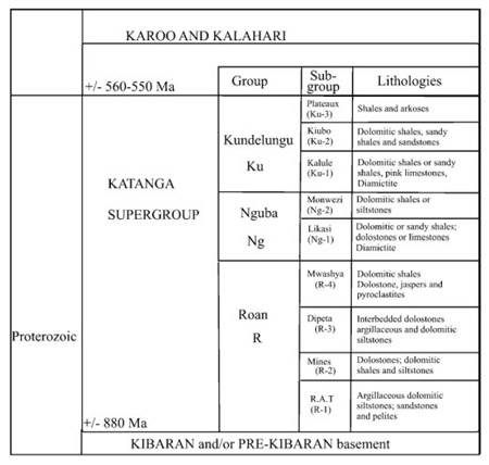
The Kundelungu Supergroup formations encountered in the Lufilian Belt and conditions of deposition are summurised below:
- Roan Group rocks were deposited in a basin that evolved from a continental rift and probably (but with no real evidence of an oceanic crust) up to an oceanic stage (Afar/Red-see type) (Kampunzu et al., 1993, 2000; Tembo et al., 1999);
- Mwashya Subgroup (belonging to Roan Group) and Nguba Group rocks are assumed to have been deposited in a wide basin (Buffard, 1988; Cailteux et al., 1994);
- Kundelungu Group is taken to represent the inversion from extensional to compressional tectonics (Batumike et al., 2002; Kampunzu et al., 2003; John et al., 2004).
The ore deposits of the Lufilian Belt are mainly hosted in the Neoproterozoic Roan group composed principally of dolomites, shales and siltstones. The main Cu-Co stratiform mineralisation is hosted more specifically in the Mines series (Roan group), principally observable in DRC. The origin of these deposits are debated around three metalogenetic models: sedimentary, diagenetic or hydrothermal.
Tectonic evolution
The rifting phase and ocean evolution during which the Kundelungu Supergroup was deposited was followed by a phase of compression resulying in subduction of the ocean crust and collision between the Congo and Kalahari cratons. The Lufilian Orogeny refers to the collisional event which marked particularly the Lufilian Belt and occurred ca. 550 Ma ago. It affected, in the Lufilian and northern Zambezi Belts, the entire Katangan Supergroup, which endured deformation and involved the basement, which was partly reworked. This orogen marked the landscape either in Katanga and in Zambia. Different deformation structures can be distinguished and are classified in the paragraph below.
Lufilian orogenic zoning
De Swardt and Drysdall (1964) identified three structural zones (i) the Outer Lufilian corresponding to the fold-and-thrust-belt part mainly located in Katanga, (ii) the Middle Lufilian which is characterised by the Domes area, mainly in northern Zambia and (iii) the Inner Lufilian which encompasses a southern synclinorium of Katangan cover, located in southern Zambia. A more complete classification was proposed by Unrug (1988), who defined five tectonic domains associated with the Lufilian belt from north to south (from DRC to Zambia):
After Porada, 1989
- [ KA ] The Katangan « Aulacogen » or « Golfe du Katanga », acted as the foreland during the northward thrusting in the external zone of the LB;
- [ I ] The external fold-and-thrust belt. This domain is marked by the piling up of nappes (Kolwezi, Mamfwe area…). The Mines Subgroup deposits are constricted between two thrust horizons. The roof thrusts are generally folded.
In Katanga, a tectonic breccia separates the Mwashia from the Roan group (the allochthonous Mine Subgroup) (Porada and Berhorst, 2000). It would indicate that the Mwashia and Kundelungu were as well displaced.; - [ II ] The Domes area, which is represented by several pre-katangan basement inliers;
- [ III ] The Synclinorial belt. The sediments of the synclinorial belt are poorly exposed, but define large fold structures at a low metamorphic grade;
- [ IV ] The Katanga high. This domain is poorly known but would correspond to the opposite active continental margin of an “Angola plate”(Porada, 1989).
Metamorphism
A major southward dipping thrust contact separates the HP Katangan metamorphic assemblages located south to southwest of the Domes area and other MP to LP metamorphic complexes located north of the Domes area (Kampunzu and Cailteux, 1999). The grade of regional metamorphism increases from prehnite-pumpellyite facies in the northern boundary of the LB (Katanga, Congo), up to medium-pressure amphibolite facies metamorphism in the southern part of the copperbelt, near the domes area (northern Zambia) (Ramsay and Ridgeway, 1977, concerning Zambia, Lefebvre and Patterson, 1982, concerning Katanga). High pressure eclogites and whiteschists occur south of the Domes area (Vrana and Barr, 1972; Vrana et al., 1975; Cosi et al., 1992).